


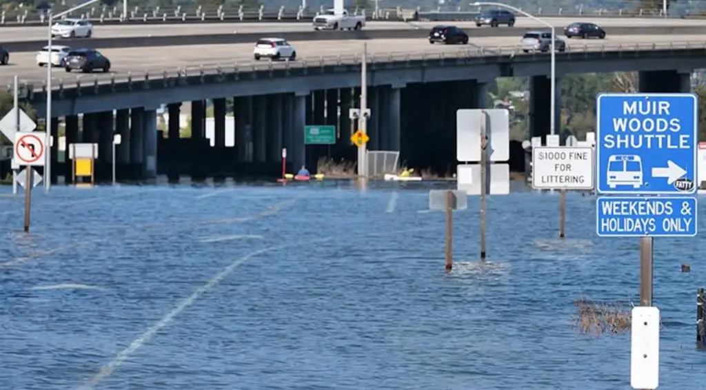
Northern California residents woke up to a surreal scene earlier this week as unusually high tides, supercharged by abnormally warm Pacific waters, spilled over sea walls and riverbanks to submerge roads, trails, and low-lying infrastructure across Marin County.
The unexpected coastal flooding, which began on October 26, 2026, transformed popular commuter routes and recreational paths just north of San Francisco into impromptu waterways. Drone footage shared by the San Francisco Standard captured the extraordinary scope of the inundation, showing kayakers paddling smoothly along a paved bike path nestled between Mill Valley and Sausalito—a corridor typically crowded with morning commuters on bicycles and runners getting in their daily exercise.
While outdoor enthusiasts found an unexpected playground, drivers and daily commuters faced a logistical nightmare. The flooding quickly overwhelmed critical local infrastructure, stranding motorists on major thoroughfares and sparking a wave of emergency responses as water levels rose at an alarming pace. Local news outlets including KTVU spotted paddleboarders navigating past stranded, half-submerged cars in Mill Valley, painting a vivid picture of a community grappling with an abnormal climate event occurring months ahead of the traditional winter storm season.
A Bad Day to Drive a Car
For motorists attempting to navigate Marin County during the peak of the tide cycle, the morning commute turned into a harrowing ordeal. Floodwaters swiftly swamped crucial portions of Shoreline Highway near the interchange with Highway 101, prompting immediate emergency road closures by local authorities to prevent drivers from getting trapped in deep water.
On nearby Miller Avenue, the situation grew even more perilous for one motorist whose vehicle became stranded as the tide surged. Water rose rapidly, reaching halfway up the doors and trapping the driver inside until a tow truck operator arrived to assist with a risky extraction, according to reports from KTVU.
Two-wheeled travelers were caught equally off guard by the speed and scale of the inundation. NBC Bay Area reported the plight of a cyclist who had ridden from Tiburon to Sausalito on October 26, only to find her return route completely blocked by a sprawling expanse of cold bay water.
According to reporting by the San Francisco Chronicle, the water rose with astonishing speed during the peak of the event on October 27. One specific stretch of Shoreline Highway transformed from dry pavement to roughly two feet of standing water in approximately 30 minutes, giving drivers and pedestrians virtually no time to adjust their routes or seek higher ground.
The culprit behind this sudden coastal surge lies in a potent mix of seasonal ocean dynamics and broader global climate patterns. According to the National Weather Service, the flooding is tied to a potentially historic Super El Niño, a recurring climate phenomenon characterized by significantly warmer-than-normal surface waters across the tropical Pacific Ocean.
Brian Garcia, a meteorologist with the National Weather Service’s Bay Area office, explained to Outside that the expansive warm ocean water has effectively raised regional sea levels, providing an unprecedented physical boost to already formidable high tides.
“We typically don’t see flooding from tides this time of year,” Garcia said, highlighting the anomaly of late-October coastal inundation. “The water actually rose higher than what we’d expect during the biggest tides of winter.”
More Water on the Way
Unfortunately for residents, commuters, and local business owners in low-lying coastal zones, relief is not arriving immediately. The National Weather Service has actively extended its coastal flood advisory through October 31, warning that subsequent high-tide cycles will continue to threaten low-lying roads, parking lots, and shoreline communities throughout Marin County’s extensive bayshore.
Authorities have urged motorists, cyclists, and pedestrians to exercise extreme caution, avoid driving through standing water of unknown depth, and monitor local forecasts closely as the advisory remains in effect.
Meteorologists and climate scientists view this week’s disruptive flooding not merely as an isolated weather quirk, but as a potential preview of a much more challenging winter season ahead. In August, University of California climate scientist Daniel Swain warned in an interview with SFGATE that the unfolding Super El Niño could persistently elevate ocean levels along the California coast, significantly increasing the probability of major coastal flooding when winter storm systems inevitably roll ashore.
According to regional projections, some of the highest astronomical tides of the year are scheduled to arrive around traditional holiday windows, including Thanksgiving, Christmas, and late January. Swain and other researchers have cautioned that if powerful atmospheric rivers or heavy Pacific storms happen to coincide with these peak high-tide windows, California could face record-breaking coastal water levels, compounding erosion risks and threatening vital transportation infrastructure from the Golden Gate Bridge northward.
As Marin County braces for what may lie ahead in the coming months, local infrastructure planners, emergency management officials, and everyday residents are being forced to adapt to a shifting coastal reality. And if the long-range winter forecasts hold true, the kayakers and paddleboarders who traded their cars for paddles this week might find themselves needing their watercraft sooner rather than later.