

For outdoor enthusiasts who live with mobility disabilities, experiencing America’s vast national parks, public lands, and trail systems has historically involved
a frustrating amount of guesswork. A weekend trip often required rolling the dice on whether a trailhead parking lot would feature packed gravel or loose sand, whether a restroom would accommodate a wheelchair, or if a miles-long excursion would abruptly terminate at an impassable step or narrow bridge.
Now, a coordinated push by federal agencies, accessibility consultants, and disability advocacy groups is working to eliminate those invisible barriers. At the forefront of this movement is a newly launched interactive accessibility map from the Bureau of Land Management (BLM), designed to connect visitors with mobility issues to trails, campgrounds, and facilities tailored to their needs. The initiative represents a significant step forward in a broader national effort to ensure that the country’s wildest spaces are open and welcoming to everyone.
A Shift in Perspective From the Heights of El Capitan
The journey toward this nationwide accessibility push is deeply personal for many of its architects. In 2017, Quinn Brett was a 36-year-old National Park Service climbing ranger whose life revolved around scaling soaring rock faces. That changed in an instant during an ascent of El Capitan in Yosemite National Park, when a 120-foot fall left her paralyzed from the waist down. Overnight, her relationship with the outdoors was fundamentally altered as she transitioned from vertical climbing to navigating the world from a wheelchair.
Like roughly one in ten Americans who live with mobility issues, according to data from the Centers for Disease Control and Prevention, Brett quickly encountered the stark realities of architectural and environmental barriers in public spaces. The challenges extended far beyond backcountry trails, often starting right at the edge of the sidewalk.
"To become disabled, and realize that I can’t even get across the street because there isn’t a curb, for instance, was quite a change in perspective," Brett told Outside.
That frustration spurred action. Brett founded Dovetail Trail Consulting, an accessibility consulting firm aimed at making outdoor spaces more usable and inclusive. Her expertise and advocacy helped shape the BLM’s new interactive accessibility map, which officially launched on October 13. The tool is designed to bridge the gap between land managers and recreationists, providing granular details about the physical conditions of public lands before visitors ever leave home.
What the BLM’s Accessibility Map Offers
The map is the culmination of a three-year project intended to help travelers plan their excursions with confidence and avoid unexpected environmental obstacles. Kevin Oliver, chief of the BLM Division for Recreation and Business Services, worked closely on the development of the mapping tool and emphasizes that the agency views the project as an ongoing commitment rather than a finished product.
"We’re going to continue to work to deliver more information and better information to the recreation public, so that all types of interests can be served," Oliver told Outside. "The BLM recognizes the work is never really done. You know, we’re always perfecting it."

The newly released map incorporates 50 existing accessible recreation opportunities across public lands. Among them is Utah’s McCoy Flats trailhead, where map entries provide precise operational details, such as the texture of the packed gravel in the parking lot, the precise layout of extended picnic tables, and the accessibility of vault toilet entrances.
Beyond currently finished sites, the tool identifies 74 additional locations where the BLM has proposed infrastructure improvements. The status of these projects varies widely. Some sites, such as Colorado’s Blue Valley Ranch Trail, are fully funded and currently undergoing construction. Others, like the Glade Run Adaptive Trail in New Mexico, remain in the planning stages while administrators actively hunt for the financial backing required to break ground.
Crucially, the BLM map relies on crowdsourced data to keep its information robust and current. Visitors can snap photographs of public lands and upload them alongside detailed descriptions of local infrastructure. This grassroots approach allows other travelers to assess trail conditions firsthand before packing their gear.
"You don’t have to do a construction project," Brett said. "Just take pictures."
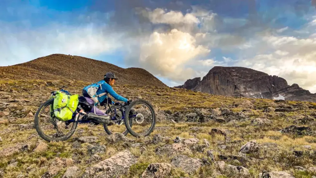
For Brett and other mobility device users, the availability of detailed data represents a fundamental shift in how they interact with nature. Modern mobility technology has evolved far beyond a single style of wheelchair, allowing users to choose from a diverse array of specialized devices designed to tackle varied terrain.
"For a long time we only had one pair of shoes to pick, but now with mobility device technology, we have a whole bunch of types of shoes that we get to choose from, and we want to go use our shoes in a variety of places," Brett said. "People with disabilities don’t want to just go to the one-mile paved trail in the busiest parts of our national parks."
Access Starts Before the Trailhead
While digital maps and infrastructure databases mark a massive leap forward, gathering data is only the first step in a much larger equation. Nonprofits and advocacy organizations emphasize that natural landscapes are dynamic environments that require constant monitoring and maintenance.
"Trails are kind of living things," Julia Ray, chief operating officer of the adaptability nonprofit Move United, told Outside. "They change with weather and seasons, so it has to be an ongoing process to keep that information current, and where and how that information is shared is still inconsistent."
Move United has been working directly with federal land managers to evaluate trail conditions, partnering with Mount Rainier and Grand Canyon National Parks to assess more than 17 miles of terrain for accessibility hazards. In addition to fieldwork, the organization has developed a free trail-access course designed to educate local land managers on federal accessibility standards and best practices.

Ray notes that focusing assessments on popular, high-traffic trails is an effective strategy for maximizing inclusion, as these are naturally the places where the greatest number of people want to go. By investing energy into auditing and upgrading these heavily visited corridors, land agencies can invite a broader segment of the population to share in the national park experience.
"If the public go to a trail more than others, that’s probably where anybody else would want to go as well," Ray said. "Everybody deserves the right to access the outdoors, and we are just really excited that there’s some energy around this right now."
Moving Beyond the One-Mile Paved Trail
For outdoor enthusiasts navigating physical disabilities, comprehensive trail data transforms the planning process, replacing anxiety and guesswork with informed choice. Having precise metrics on slope, surface density, and potential obstacles allows users to determine what equipment to pack, how much physical challenge to anticipate, and whether a given route matches their comfort level.
Brett’s personal drive to explore the mountains remains as strong as it was before her accident, rooted in a lifelong passion for wild, challenging environments.
"I still want to be playing and going to the top of mountains and doing wild and crazy things," Brett said. "But I also need the information to decide what experience I want."
She emphasizes that involving individuals with disabilities directly in trail assessments is essential for uncovering hidden design flaws that able-bodied planners might easily overlook. While modern adaptive equipment can often negotiate natural obstacles like rocks, roots, and uneven earth, manufactured infrastructure can sometimes create sudden, unexpected dead ends.
"Five miles of the trail might work totally fine, and then there’s a bridge to cross some water, and they just threw down a 12-inch bridge, and after that, there’s five more miles of trail that work just fine," Brett said. "But if you’ve never hung out with somebody with a disability, then you might not know what is truly a barrier."