



the AI Boom: New Project Tracks Hundreds of Data Centers Near America’s National Parks
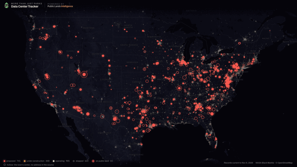
As the United States grapples with the staggering and rapid proliferation of artificial intelligence, a pair of resourceful brothers has set out to bring transparency to an industrial expansion largely unfolding under the radar. Across the country, the soaring computational demands of artificial intelligence and cloud-based software are driving an unprecedented wave of infrastructure development. To help citizens navigate this sprawling landscape, independent researchers have built a comprehensive national mapping tool designed to track proposed data center projects right up to the borders of public lands and iconic national parks.
Will Pattiz, cofounder of More Than Just Parks—an independent public lands publication tracking the modern footprint of AI infrastructure—spearheaded the initiative alongside his brother. According to their meticulous research, at least 14 proposed data center projects are currently slated to be built within a ten-mile radius of a national park boundary. Looking slightly broader, the data reveals that 38 sites are planned within 25 miles of a national park, while an astonishing 131 projects are targeted within a 50-mile radius of these protected natural sanctuaries.
Speaking with Outside, Pattiz, a resident of Portland, Oregon, explained the urgent motivation behind the mapping project. He noted that a significant portion of these high-stakes infrastructure deals are being pursued with little public awareness or localized input.
"The basic idea is that a lot of these projects are being done under the cloak of darkness or secrecy, and we want folks to know where they’re coming in and who’s building them," Pattiz said. "The stance that we take is that we don’t want them on public lands."
He pointed specifically to states like Utah, which have emerged as focal points for massive data center proposals. Because of the sheer physical size and massive computational scale of these facilities, they demand staggering amounts of natural resources. Whether they are drawing heavily from local municipal water supplies or permanently altering sensitive terrain, Pattiz emphasized that these developments will inevitably leave a heavy mark on public lands one way or the other.
Data Center Sprawl Across the United States
The nationwide surge in data center construction is fundamentally tied to the exponential rise of artificial intelligence models, machine learning systems, and extensive cloud-based software networks. Inside these massive facilities, rows upon rows of high-density servers, vast data storage arrays, and complex networking hardware operate around the clock. Keeping this sophisticated equipment functional and cool requires immense amounts of electricity and water, transforming quiet regions into heavy industrial hubs almost overnight.
"The question that we want to see asked is: ‘What is the public benefit from this?’" Pattiz said, highlighting the core dilemma facing local communities. "So far, the ones that have been proposed on public lands, there’s no public benefit that’s been outlined."

To bridge the information gap, the brothers designed the mapping tool with user accessibility in mind. By simply inputting a local zip code into the interactive platform, a user can instantly pull up the closest operating data center or newly proposed facility. The digital tool goes a step further by offering insights into how the specific installation might influence local utility costs, while also identifying the corporate or political groups actively supporting the development.
"You can go through that discovery process yourself to decide whether you support the center or not, because these are things that are going to impact all of us, and you can decide where you land on that," Pattiz said, emphasizing that the tool is meant to empower everyday citizens with verifiable facts rather than dictate their political stances.
Proposed Data Centers Nationwide
The digital tracking map is dynamic, auto-populating with fresh data as municipal filings, zoning applications, and environmental assessments become publicly available. As of late 2026, the comprehensive tool reflects a staggering total of 2,086 data centers cataloged nationwide. Out of that total, 741 facilities are still navigating the precarious proposal and permitting phases.
Of those active proposals, roughly 77 are situated within a ten-mile radius of protected public lands, including national parks, national wildlife refuges, and designated wilderness or conservation areas. Geographically, about half of these pending projects are concentrated in the American West, where vast expanses of federal land and relatively cheap energy sources have made them prime targets for tech developers.
The trends vary heavily by region. In Virginia, a notorious hub for digital infrastructure, 97 data centers are currently proposed, with 12 situated within 25 miles of Shenandoah National Park. Meanwhile, in the Midwest, at least 25 data centers have been proposed in Indiana, according to the tracking map, with eight located within a 25-mile radius of Indiana Dunes National Park.
Beyond regional concentrations, the map highlights several high-profile construction proposals situated alarmingly close to iconic National Park Service sites, where environmentalists and local residents are already pushing back against the encroaching industrial footprint.
Horseshoe Bend in Page, Arizona
Arizona alone accounts for 26 active data center proposals, with three situated within 25 miles of a national park boundary. The tension between tech expansion and scenic preservation came to a head in January, when the City of Page finalized the sale of roughly 500 acres of land to developers who are planning to build a massive $10 billion data center complex right next to Horseshoe Bend. This dramatic, horseshoe-shaped incised meander of the Colorado River is one of the most photographed and heavily visited viewpoints in the American Southwest.
Significantly, the 500-acre parcel in question had previously been protected and utilized for outdoor recreation. While the City of Page has noted that the high-stakes proposal is still undergoing formal public review and has not yet been officially adopted, municipal planning and zoning meetings continue to move forward, drawing intense public scrutiny.

According to Pattiz’s mapping data, the proposed Horseshoe Bend facility is also located approximately five miles from the northeastern edge of Grand Canyon National Park near the historic Lees Ferry area, raising additional concerns regarding regional water consumption and environmental degradation along the river corridor.
Project Beehive in Utah
In Utah, large-scale energy and tech proposals have sparked fierce debates over resource allocation. Just outside the city of Price, Pattiz discovered that a private company named Valar Atomics had applied for more than 9,000 acres of public land managed by the Bureau of Land Management. The sprawling application is intended for extensive data center buildouts, accompanied by ambitious permits for hundreds of small modular nuclear reactors, a dedicated fuel processing plant, and localized nuclear waste storage facilities.
According to a detailed report published by NPR, the initiative—widely known as Project Beehive—would generate roughly 9.6 gigawatts of power dedicated exclusively to fueling the data centers. To put that staggering figure into perspective, NPR reported that the entire state of Utah currently produces less than half of that electrical output on average from its existing grid infrastructure.
The targeted public land lies roughly a two-hour drive from both Arches National Park and Canyonlands National Parks, prompting immediate alarm among conservationists who worry about the long-term ecological and hydrological integrity of the surrounding desert landscape.
Antelope Data Center in Cedar City, Utah
Further south, the proposed Antelope Data Center in Cedar City, Utah, represents another major infrastructure hurdle for the region. Located roughly 40 miles from the dramatic sandstone cliffs of Zion National Park, the facility is slated for development as part of a sprawling 640-acre, 1.5-gigawatt project. According to reporting from The Salt Lake Tribune, the industrial site is designed to include its own on-site natural gas power plant to guarantee a steady, uninterrupted energy supply for the servers. The Iron County Commission ultimately approved a conditional use permit for the controversial project, clearing the path for future development despite lingering local concerns.
What’s Next?
The rapid, nationwide rollout of large-scale data centers marks a profound inflection point in modern American history. As heavy construction crews continue to break ground on these massive facilities, they have increasingly transformed into volatile political lightning rods in small towns and sprawling metropolitan areas alike.
Pattiz firmly believes that providing everyday Americans with transparent, easily accessible information regarding where big tech companies are acquiring land will play a vital role in helping communities monitor what is being built right in their own backyards.
"At the end of the day, data is data," Pattiz added, emphasizing the core mission behind the nationwide mapping project. "Whether or not there’s a need for these things is a totally separate question from where they’re being built and what impact they’re going to have on you and the places that you love."